
The Lagos State Government has commissioned a new Land Archive designed to securely store physical and electronic land records, as the state intensifies the digital transformation of land administration and urban planning through its electronic Geographic Information System.
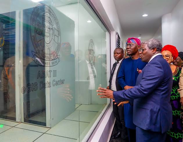
Governor Babajide Sanwo-Olu opened the facility on Tuesday during a guided inspection of Lagos’ geospatial infrastructure held to mark the state’s maiden GIS Day 2026.
The government described the completed archive as the largest land information storage facility in West Africa, combining dedicated storage for physical land documents with electronic data-management systems.
Construction of the facility began in 2025 and forms part of a broader programme aimed at modernising how Lagos collects, stores and uses information about land, infrastructure and physical development.
The initiative is expected to strengthen the state’s ability to manage its rapidly changing urban environment by providing government agencies with more organised and accessible spatial information.
Archive to Secure Lagos Land Records
The Lagos Land Archive was designed primarily as a central repository for hardcopy land documents.
Its completion gives the state a purpose-built facility for preserving records that form an important part of property administration, ownership documentation and development planning.
At the same time, the inclusion of electronic storage reflects Lagos’ wider transition from predominantly paper-based land administration towards digital systems.
The combination is particularly important because digitising government processes does not immediately eliminate the need to preserve original historical records.
A properly organised archive can therefore provide the physical foundation for the state’s broader digital land-information programme.
Sanwo-Olu toured the new facility alongside members of the State Executive Council and officials involved in land administration and urban development.
Lagos Expands Geospatial Infrastructure
The Governor’s inspection extended beyond the archive to departments responsible for building and operating the state’s geospatial systems.
They included the Lagos State Physical Planning and Automation Department, Survey Information Centre, GIS Centre and Office of the Surveyor-General of Lagos State.
Officials demonstrated newly developed technologies intended to convert spatial information into practical tools for land administration, physical planning, infrastructure monitoring and government decision-making.
Geographic Information Systems allow different forms of data to be connected to particular locations.
For a densely populated and continuously expanding city such as Lagos, that can help government understand not simply what infrastructure or development exists, but precisely where it is located and how different assets relate to one another.
Sanwo-Olu: Lagos Requires Better Spatial Intelligence
Sanwo-Olu said the complexity and scale of Lagos made accurate geospatial information increasingly important to effective governance.
“Lagos is a city of extraordinary scale, complexity and one that undergoes constant change. To understand and manage this territory, plan its infrastructure and respond effectively to the needs of its people, we must be able to understand the State not only through what we see, but through the information that tells us where things are, how they connect and how they change.”
The Governor said this ability to understand relationships between locations, infrastructure and development demonstrated the importance of geospatial information.
The technology can potentially support decisions involving roads, housing, drainage, public facilities, land allocation and other areas where accurate location data is essential.
e-GIS Journey Started in 2016
Special Adviser to the Governor on eGIS and Urban Development, Dr Olajide Babatunde, said Lagos began developing its current geospatial capabilities in 2016.
According to him, the state subsequently implemented the project in stages, gradually developing the systems now supporting its e-GIS infrastructure.
He said the technology had strengthened the collection, organisation and use of spatial information across government.
The maiden GIS Day, Babatunde added, provided an opportunity to assess that progress and recognise the institutions involved in developing the state’s geospatial capabilities.
LAGIS to Bring Systems Together
Babatunde also highlighted the institutionalisation of LAGIS, describing it as an important stage in bringing Lagos’ various geospatial activities under a stronger framework.
“The institutionalisation of LAGIS represents an important step in bringing this work together and establishing a stronger framework for the way Lagos creates, manages and uses spatial information,” he said.
Bringing information into an integrated framework could become particularly important as multiple government departments increasingly depend on the same underlying geographical data.
Rather than agencies maintaining disconnected records, an integrated system can potentially improve coordination and reduce duplication.
Digital Land Administration Could Improve Planning
The wider importance of the programme lies in how Lagos ultimately uses the information stored and generated by the system.
Land administration has traditionally involved significant volumes of documentation and interactions across multiple government offices.
Digital systems can potentially make records easier to retrieve, improve tracking and provide planners with more accurate information about development across the state.
However, the value of the investment will depend on the reliability of the underlying records, continued digitisation and how effectively government agencies integrate the technology into their daily operations.
Data security will also be important because land records contain sensitive information with significant legal and financial value.
For Lagos, where rapid population growth and physical expansion continually place pressure on infrastructure and available land, accurate spatial information is becoming increasingly central to urban management.
The commissioning of the Land Archive therefore represents more than the opening of another government building.
It forms part of Lagos State’s effort to build a digital information infrastructure capable of supporting how one of Africa’s largest urban economies manages land, plans development and makes infrastructure decisions.